You are using an out of date browser. It may not display this or other websites correctly.
You should upgrade or use an alternative browser.
You should upgrade or use an alternative browser.
Mojave Road Christmas Run
- Thread starter Motiracer38
- Start date
Motiracer38
Well-known member
- Joined
- Apr 27, 2022
- Messages
- 522
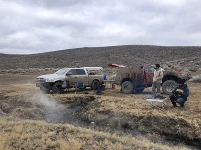
I'm not a fan of mud either, still have a bit of fab to do underneath and don't need the endless pixie dust falling out.
Roll Call-
1- Motiracer38 Sequoia and family
2- Turboyota with a Yota con turbo and adult son
3- Sdecurti (4runner) equal odds on bringing the slow one or the rockcrawler
4- Luxlander (ram 1500) with all the camping gear
5- Dave Marsh (Bronco) and son
6- Bromaninan Fraptor and son
Sounds like a good group of equally capable rigs so should go smooth if we don't get stuck in the mud. Detours for full washes are probably.
Meeting time is Saturday, 8AM at Robertiroz and roll out from there at 9AM with full bellies and full gas tanks.
My radio will be on BFG-PIT 153.395.
GPS file is still in work
badlinesgoodtimes
Administrator
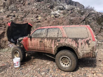
Scotty loves mud. circa 2013


Motiracer38
Well-known member
- Joined
- Apr 27, 2022
- Messages
- 522
I had forgotten the wash was so wet, only remember crossing the 100ft wide river on Harvard Rd. That was a good time.
badlinesgoodtimes
Administrator
Mojave River is no joke
https://en.wikipedia.org/wiki/Mojave_River

https://pubs.usgs.gov/of/2004/1007/river.html
This drainage system evolved along with the changing landscape beginning in late Tertiary time when concurrent tectonic uplift of mountain ranges around the Mojave region and changes in regional climatic conditions were occurring. The modern river system began developing as westward-flowing stream drainages were blocked by the uplift of the Transverse Ranges along the greater San Andreas Fault System. The combination of blocked drainage systems and increased precipitation with the onset of cooler or ice age conditions at the close of the Tertiary resulted in the filling of basins with water (and sediments). Progressively through the latest Tertiary and into the Quaternary periods, lakes filled and stream overflowed through low divides between ranges and flooded adjacent basins. In this manner, the Mojave River evolved from the spilling over of lakes in the western Mojave Desert region. These large lakes do not exist today. Two large lakes that played perhaps a most significant role in the development of the landscape in the Mojave National Preserve area were Lake Manix and Lake Mojave. Sediments associated with these ancient lake deposits (and others in the region) record a story of climate change in the region.
Lake Manix was a large inland lake that was located in the Barstow, CA region (dry Troy Lake and Coyote Lake are remnants of this larger lake basin), and Mojave Lake in the Baker, CA region (dry Silver Lake and Soda Lake are remnants of this ancient lake basin). The development of these lakes and other lakes in the region was progressive with time, with Manix Lake filling first, and Mojave Lake forming later when the Lake Manix filled to capacity and spilled westward, ultimately carving Afton Canyon during the last glacial maximum about 18,000 years ago (Jefferson, 2003).
https://en.wikipedia.org/wiki/Mojave_River
https://pubs.usgs.gov/of/2004/1007/river.html
The Mojave River and Associated Lakes
The Mojave River is the largest drainage system in the Mojave Desert. It's modern extent and capacity is only a fraction compared to its extent during the Last Glacial Maximum. At its peak during this last ice age, the Mojave River drainage basin extended from the San Bernardino Mountains in the west; it flowed east and north ultimately merging with the Amargosa River before draining into Lake Manley in Death Valley. At this peak period, waters of the Mojave River drainage system flowed through, or contributed water to, several great Pleistocene Lakes: Lake Manix (which incorporated modern dry lake basins Afton, Troy, Coyote, Harper, and Cronese basins), and Lake Mojave (including dry Soda Lake and dry Silver Lake basins)(see the map on the Changing Climates & Ancient Lakes page). Today Soda Lake is the current terminal point of the Mojave River (although it has flowed into Silver Lake in historic times).This drainage system evolved along with the changing landscape beginning in late Tertiary time when concurrent tectonic uplift of mountain ranges around the Mojave region and changes in regional climatic conditions were occurring. The modern river system began developing as westward-flowing stream drainages were blocked by the uplift of the Transverse Ranges along the greater San Andreas Fault System. The combination of blocked drainage systems and increased precipitation with the onset of cooler or ice age conditions at the close of the Tertiary resulted in the filling of basins with water (and sediments). Progressively through the latest Tertiary and into the Quaternary periods, lakes filled and stream overflowed through low divides between ranges and flooded adjacent basins. In this manner, the Mojave River evolved from the spilling over of lakes in the western Mojave Desert region. These large lakes do not exist today. Two large lakes that played perhaps a most significant role in the development of the landscape in the Mojave National Preserve area were Lake Manix and Lake Mojave. Sediments associated with these ancient lake deposits (and others in the region) record a story of climate change in the region.
Lake Manix was a large inland lake that was located in the Barstow, CA region (dry Troy Lake and Coyote Lake are remnants of this larger lake basin), and Mojave Lake in the Baker, CA region (dry Silver Lake and Soda Lake are remnants of this ancient lake basin). The development of these lakes and other lakes in the region was progressive with time, with Manix Lake filling first, and Mojave Lake forming later when the Lake Manix filled to capacity and spilled westward, ultimately carving Afton Canyon during the last glacial maximum about 18,000 years ago (Jefferson, 2003).
the bodj
Well-known member
Did you count my truck in the 2 or 4 wheel drive group?March 2023: the most water I’ve ever seen in Afton.
We had two 4WDs and four 2WDs
View attachment 46793View attachment 46794View attachment 46795

badlinesgoodtimes
Administrator
You were in the S10 CategoryDid you count my truck in the 2 or 4 wheel drive group?
badlinesgoodtimes
Administrator
I'll be here web wheeling during this trip if anyone needs me...  FOMO meter is already pegged...
FOMO meter is already pegged...Turboyota
Well-known member
- Joined
- Apr 1, 2022
- Messages
- 1,017
Did you count my truck in the 2 or 4 wheel drive group?
Neutered empty beam category
Turboyota
Well-known member
- Joined
- Apr 1, 2022
- Messages
- 1,017
Wasn’t there an abandoned Geo Tracker or Isuzu Trooper (or something else obscure) in the middle of the road as we crossed?I had forgotten the wash was so wet, only remember crossing the 100ft wide river on Harvard Rd. That was a good time.
SByota
Well-known member
Yes, something small with a snapped front solid axle. Wyatt still talks about it. You saidWasn’t there an abandoned Geo Tracker or Isuzu Trooper (or something else obscure) in the middle of the road as we crossed?
“ well someone is having a bad day” over the radio.
Motiracer38
Well-known member
- Joined
- Apr 27, 2022
- Messages
- 522
Yeah I'm hoping the good forecast holds, just gotta fit enough wood in to keep the chill off at night.
Oldmanadam
New member
- Joined
- Oct 3, 2022
- Messages
- 3
Scotty loves mud on his truck’s very first trip.Scotty loves mud. circa 2013
Attachments
84Prerunner
Well-known member


 mud
mud