sixdee9er
Well-known member
I use google earth almost everyday for work and I have collected an extensive layer list of not only things for work, but also those for play. I regularly find myself slacking off and exploring new areas that I want to visit.
I also use google earth for all my trip planning. I draw as a path, export to KML, and add to my Gaia app. It works pretty flawlessly.
Some of the more useful layers I have added include national parks, Wilderness Areas, Indian Reservations, Military Areas, and I even have a Mining Layer of all the mines in CA/AZ. I also have all my previous trips saved so i can revisit or re-use as needed.
Most useful layer I think I have come across is definitely the Wilderness areas. While those areas are no-go for motor vehicles (thank you Dianne Feinstein )there are alot of little bypasses or out-and-back routes that were left open for access.
Any useful layers or info that I have over looked? Share them here. I'd also be glad to share any of those public layers that I have downloaded.
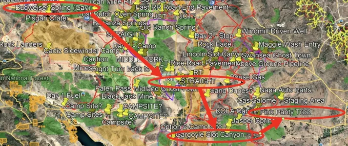
Screenshot of mine below:
Green = National Parks/Wilderness Areas
Orange = Military/Indian Rez
Lines = Trails I have mapped
Placemarks are my personal points of interest.

Example of a Wilderness area with a small road left open:

I also use google earth for all my trip planning. I draw as a path, export to KML, and add to my Gaia app. It works pretty flawlessly.
Some of the more useful layers I have added include national parks, Wilderness Areas, Indian Reservations, Military Areas, and I even have a Mining Layer of all the mines in CA/AZ. I also have all my previous trips saved so i can revisit or re-use as needed.
Most useful layer I think I have come across is definitely the Wilderness areas. While those areas are no-go for motor vehicles (thank you Dianne Feinstein
)there are alot of little bypasses or out-and-back routes that were left open for access.Any useful layers or info that I have over looked? Share them here. I'd also be glad to share any of those public layers that I have downloaded.
Screenshot of mine below:
Green = National Parks/Wilderness Areas
Orange = Military/Indian Rez
Lines = Trails I have mapped
Placemarks are my personal points of interest.
Example of a Wilderness area with a small road left open:


 fabulous