CARRIZO PLAIN WEEKEND TRIP 2026

WW_RANGER_X

Well-known member
Joined
May 3, 2022
Messages
753
Location
Visalia, Ca.
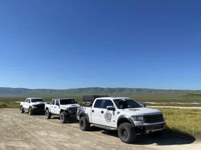
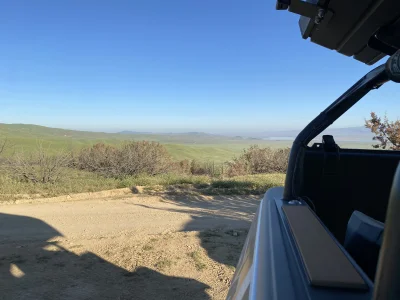
I had no idea this place even existed until a couple of months ago when I was playing around on my On X Offroad app and found a trail report for Elkhorn Rd. Thought of going out solo, but once I talked to my brother and and another friend about it they were down to go see what it was all about. The cool thing for us is it’s only a 2 hour drive from Visalia. I will do a full trip report here soon. I just wanted to start this to get the ball rolling. To be continued!

DJI_0272.webp
 
The line up.

-Gladiator
-Raptor
-TRX

Saturday (3-21) we met at an AMPM here in Visalia at 5:45am to hit the road south west. This area is in between Bakersfield and Santa Maria, ca off of the old 58 highway. It’s actually considered Santa Margarita. It’s about 2-2.5 hours from my driveway. We hit dirt (Elkhorn Rd.) at about 8:30am after a breakfast stop.

IMG_3571.webp

IMG_3573.webp

IMG_3574.webp

After hitting dirt for a few miles we stopped at Wallace Creek trail head. This is where you can walk/hike for about 30 mins to see the San Andreas fault line. We opted out on doing the walk due to a rattle snake warning in the area, so Gladiator Steve busted out the drone and flew over. Said it wasn’t anything exciting so we pressed on.
We headed south on Elkhorn rd, passed a bad ass private property spot where a cowboy and his dogs were wrangling up a wondering cows (no pics of that). Farther down the road we came to a T where we could go right, back down into the valley or left up a trail called Hurricane. So we headed left and started to climb in elevation rapidly.

IMG_3576.webp

IMG_3575.webp

IMG_3581.webp

Once we made the climb up to about 2000 feet we came up to a Carrizo Plain sign. Little did we know there was a ton of traffic behind us, including a group of dual sport guys who stopped to talk to us while at the sign. They gave us a run down on the trail we were about to take after leaving the sign if we wanted to, or just head back down into the valley with all the hippies and Subarus. So we head up a little more to the “trail head” of this Ridgeline trail. Little did we know we were going to spend the next 6 hours on this trail.

IMG_3585.webp

IMG_3586.webp

IMG_3590.webp

IMG_3591.webp

IMG_3594.webp

IMG_3596.webp

IMG_3598.webp

IMG_3601.webp

IMG_3605.webp

IMG_3609.webp

IMG_3611.webp

IMG_3612.webp

TBC…
 
We were on this trail for a few hours. Mind blowing views that pictures don’t do justice. Not a flat spot in sight. Every time you think the trail is going to start descending in altitude the next hill climb is taller than the one before. And just to put this info perspective, I don’t think a 2wd vehicle could do this in my opinion, unless they have a locker, big balls and a ton of HP. So after hours on this ridge line trail we finally found the end where we started descending back down into the valley which led us back to Elkhorn Rd. It’s getting late so it’s time to find a place to camp. We made our way to KCL camp. Completely full. Then we headed to Selby Camp. Full. All spots were taken in both camp grounds, which were 45 mins from each other. So we head up Caliente mt. Rd (which is north west of Selby camp ground) to find a dispersed camp site somewhere off the road. Luckily we found the only spot left along the road big enough for 3 vehicles.

IMG_3642.webp

IMG_3614.webp

IMG_3616.webp

IMG_3622.webp

IMG_3624.webp
 
looks rad, kinda reminds me of the trails up the 395 and owens valley. just mellow scenic stuff the entire time.
 
after a few beers we all crashed out. Well, kind of. It was so quiet out there It was hard for me to sleep. I mean, you couldn’t hear a thing, or could hear anything if that makes sense? lol. Heard a pack of coyotes off in the distance almost all night. I need to get a sound machine for the RTT or something.
Anyways, the morning came and it was beautiful. Slight breeze and it was already getting warm. So we packed up to head home. Heading down Caliente Mountain Rd we saw this guy…

IMG_3648.webp

We drove around him and let him be. I ain’t fucking around with a snake lol. Once we got down to the valley floor we headed north around Soda Lake for our last stop.

IMG_3628.webp

IMG_3627.webp

IMG_3629.webp

IMG_3630.webp

IMG_3632.webp

We exited the area the same way that we entered, down the old highway 58. We originally planned to exit on the southside and take the 166 to the 5 home but since the camp grounds were full we were closer to the north side where we ended up camping. As we got into Buttonwillow on our way home we all got notifications that the 99 was closed in both directions due to a semi truck crash. A freakin Amazon truck blew its load all over both directions. So we ended up finding a route through Kettleman City off the 5 and just bobbed and weaved our way home. Quick but amazing trip! I want to do more like this for sure. Overall mileage was 352 with 90 of those miles being dirt. It’s crazy knowing this was in my “backyard” this whole time and I didn’t hear about it until a couple of months ago. Most of these pics were just what I took with my shitty old iphone. I will continue to post much better pics of the trip from the other dudes that were with me with much better cameras. Thanks for following along!

IMG_3634.webp

IMG_3639.webp

IMG_3636.webp

IMG_3637.webp
 

Attachments

  • IMG_3631.webp
    IMG_3631.webp
    723.1 KB · Views: 0
  • IMG_3623.webp
    IMG_3623.webp
    1 MB · Views: 0
Back
Top